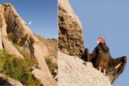
 With help from my favorite hiking partner, Chris, I finally made it to the highest point in the McDowell Mountains yesterday (4069ft). We started at 4:45am from the North Access and followed a climber’s trail through Mesquite Canyon, up over the 3 Svens, past Marcus Landslide and then up to East End. There’s a Geo cache hidden in the rocks up there with an “I made it” book and I was stoked to be able to add my name 🙂 Rather than go back the way we came, we then followed another climber’s route over to the Tom’s Thumb trail which took us back to the trail head. Four hours and a little more than 1500 ft elevation gain….it was awesome!
We saw deer and the remains of a deer which reminded us there are Mountain Lions up there but we didn’t see one (I was disappointed!). We did, however, see this guy which was pretty cool too. We had stopped to look at the view and after a few minutes, I did what a good photographer should always do and that is to turn around and shoot in the other direction too. This is what I saw. I was so excited I could hardly hold my camera still and wished I could have stayed to see him take off.
Sigma 18-250mm OS (perfect lens for long hikes), ISO 400, f/8, 1/640th sec.
![]() I checked on the Arizona Queen of the Night this morning and there is only a very slight increase in the size of the flower buds. From the information I’ve been reading, it seems a little late for them to be blooming but this has been a strange year. Unfortunately, I have a couple of trips coming up so I will probably miss the event 🙁
I checked on the Arizona Queen of the Night this morning and there is only a very slight increase in the size of the flower buds. From the information I’ve been reading, it seems a little late for them to be blooming but this has been a strange year. Unfortunately, I have a couple of trips coming up so I will probably miss the event 🙁